Wye Downs Circular – North Downs Way Rail Trail
A scenic climb along the North Downs Way National Trail from the historic village of Wye, taking in the Devil's Kneading Trough and the Wye Downs, as well as the Wye Crown Geosites. Wye’s parish church of St Gregory and St Martin has Saxon origins, later rebuilt and expanded, and was an important stop for pilgrims travelling to Canterbury. The Junipers in Wye take their name from juniper bushes that once grew on the chalk downs above the village. Nearby, St Eustace’s Well was a medieval pilgrimage site believed to cure a range of ailments. The Wye Crown is a Chalk Monument Geosite above Wye, carved in 1902 for Edward VII’s coronation, remains a striking landmark, with ancient hollows nearby formed from early ironstone extraction. The Devil’s Kneading Trough is also a Geosite; a dramatic dry valley formed by Ice Age erosion, later associated with folklore and used for military training during World War II. Today it is a protected National Nature Reserve, valued for its chalk grassland, wildlife, and far-reaching views across Kent.
ROUTE STEPS
- Turn left out of the train station. Walk past the Tickled Trout pub and follow the road to the left and as it bends again to the right until reaching the Co-op and Wye Church.
- Take the diagonal footpath marked North Downs Way (NDW) and Stour Valley Way through the churchyard, following waymarkers along an enclosed alley past allotments. At the end of the alley, turn right and follow North Downs Way waymarkers to the road.
- Cross over the road, passing Wye School and up a rough tarmac road. Go through the metal gate at the end. Continue straight along a stone track that becomes steeper as it nears a road. This is all part of the North Downs Way.
- Cross the road and follow the North Downs Way straight up a steep hill to the edge of woodland. There is a bench here to rest. Go through the gate and follow the path through woods and up a steep well surfaced path to meet a road. Turn onto the road.
- After 250m, turn right up a smooth surfaced slope to follow the NDW. Go through a scissor gate and follow field edge and through a second scissor gate. Turn immediately left and follow the NDW along the fence line. There are great views to the right as well as a rest area, a commemorative plaque and the Wye Crown – a Chalk Monument Geosite.
- Follow the fenceline as it bends to the left and continue straight across an open section of grass and undulations until reaching a gate. Warning – there are sometimes cows grazing in this field.
- Go through the kissing gate and follow the North Downs Way on a long stretch of bridleway on top of the Downs where sheep often graze. Go through a gate, and after a short section of path turn right to cross the road to another gate and an information panel for the Wye National Nature Reserve.
- Go through the kissing gate and bear left on a bare earth path through a small area of woodland. At the next gate follow the NDW sign to bear right over a grassy area and go through another gate. There is a picnic bench on the left.
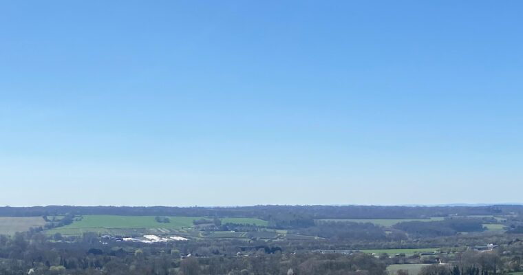
- Walk down the grassy slope ahead and go through the kissing gate on the right, leaving the NDW. Walk straight ahead enjoying views of the Devil’s Kneading Trough and the Wye Downs Geosite. At the end of the path, stop to enjoy far reaching views of Brook, Wye and on a good day, Dungeness in the distance.
- Straight ahead take a series of steps down the steep hillside. These are arranged in 6 flights of 24, 30, 7, 26, 5, 11 and 115 steps with narrow, slippery sections in between. At the bottom, go through a gate. Keep to the left-hand side past a rest bench and turn right down a short muddy chalky slope to another kissing gate.
- Turn right onto the road, then left at the footpath sign after 40m. Cross the field diagonally, then walk straight ahead keeping the hedge line to the left. Walk past the next hedge on the left, turn slight left and immediately right, keeping the next hedge to the right. Effectively, walk straight ahead until reaching a small road.
- Continue straight to cross a small road, then onto a stony track and another road.
- Bear left as the road bends and take the footpath to the right of the football field. Go straight, cross Orchard Drive, and continue along Cherry Garden Lane to reach Upper Bridge Street.
- Bear left on Upper Bridge Street and walk straight down the road to reach Wye Station.