Skip to content
Go back
menu
Visit & Explore
Aspiring Cross-Channel UNESCO Global Geopark
Aspiring Cross-Channel UNESCO Global Geopark
Save Aspiring Cross-Channel UNESCO Global Geopark to favourites
GeoAdventures
Save GeoAdventures to favourites
Geosites
Save Geosites to favourites
Cross-Channel Geopark Festival
Save Cross-Channel Geopark Festival to favourites
SALT + EARTH Festival
Save SALT + EARTH Festival to favourites
#UptheKentDowns
#UptheKentDowns
Save #UptheKentDowns to favourites
Top Downs
Save Top Downs to favourites
Settle Downs
Save Settle Downs to favourites
Activities
Walking
Cycling
Horse Riding
View all
activities
Places to Visit
Beaches
Parks & Open Spaces
Woodland
Rivers & Lakes
Outdoor Gyms
View all
places
Experiences & Itineraries
Culture & Heritage
Arts & Crafts
Wellbeing
Food & Drink
Family Fun
Wildlife & Nature
Pilgrimage
Outdoor Activities
Farming & Animals
View all
Experiences and Itineraries
The North Downs Way National Trail
The North Downs Way National Trail
Save The North Downs Way National Trail to favourites
North Downs Way Art Trail
Save North Downs Way Art Trail to favourites
Events
How to get here
Blog
Conserve
What is special about the Kent Downs?
Climate Change and the Kent Downs
New Duty to Seek to Further
Respect, Protect, Enjoy
Volunteering
Tree Planting
Landscape management
Farming in Protected Landscapes
Management guidance and publications
Kent Downs Management Plan Review 2026 – 2031
Management guidance and publications
Management Plan
Landscape Character Assessment 2020
Tree Planting
Natural Flood Management
Viticulture in the Kent Downs
Planning
Planning overview
Planning protocol
Planning publications
National Planning Policy Framework
Planning and the Management Plan
Boundary Map
Business Resources
Business Resources
Work with us
Find a North Downs Way Ambassador
Education
Education walks for children
Useful teaching materials
How to guides
Activity sheets
Geopark Education Resources
Projects
UNESCO Sites Across the Channel
GeoDiversity
Putting Down Routes
Mapping Heritage Ponds
Protect Our Pollinators – Making Trapping Happen
Farming in Protected Landscapes
Farming in Protected Landscapes
Farming in Protected Landscapes: Indicative Projects
Discover the Darent Valley Landscape Partnership Legacy
North Kent Woods and Downs
National Nature Reserve (NNR)
Undergrounding
The Kent Downs Trust
Past projects
EXPERIENCE
Mid Kent Downs Countryside Partnership
Orchards for Everyone
The Ash Project
Valley of Visions
Green Pilgrimage
About us
What is special about the Kent Downs?
What is a National Landscape?
Who we are
Joint Advisory Committee
National Landscape Partnership
Our partners
The National Landscape team
EU Funding
Boundary Map
Vacancies and Opportunities
Contact us
Donate
Show search
Show favourites
Close menu
Search form
Search website
Get results
Wealden Cycle Trail – Ashford to Tenterden
22nd May 2023
The Ashford to Tenterden cycle route is the perfect way to take in Kent's quintessential scenery running on small country lanes through the High Weald.
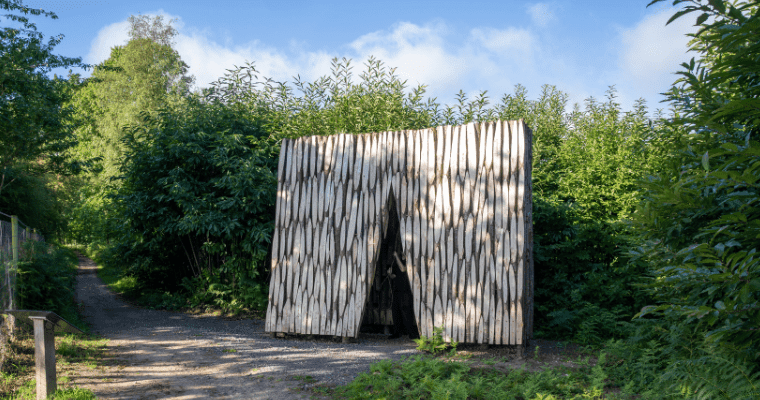
‘Coppice Oratory’ By Tchonova + La Roi
1st March 2023
Made from coppiced chestnut directly from the forest woodland, this four-metre-high wooden sculpture is a key lookout point on the North Downs Way, a space…
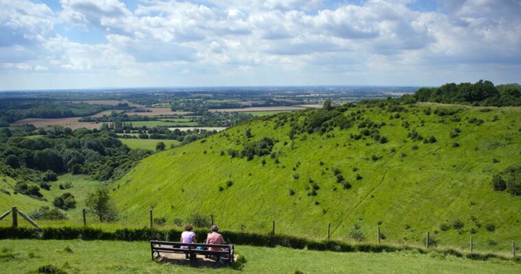
Wye Downs walk
20th January 2022
Challenging climbs through this part of the Kent Downs Area of Outstanding Natural Beauty are rewarded by spectacular views. This exhilarating circular walk leads through…
Pilgrims Cycle Trail
3rd March 2015
From the wilds of the North Downs to the inspirational City of Canterbury, you will see the best of what Kent has to offer on…
Greensand Way
3rd March 2015
Stride out along 108 miles of the Greensand Way and discover some of the finest walking experiences in the South East.
Stour Valley walk
18th February 2015
Follow the route of the River Stour from its source at Lenham, in the heart of the Garden of England, to the historic city of…
Chilham East Lost Landscapes Walk
17th February 2015
Take a leisurely stroll around the attractive landscape of Chilham and explore the Stour Valley on this 4.5 mile walk.
Chilham West Lost Landscapes walk
17th February 2015
This 4.5 mile trail heads west, through Shottenden, to the dramatic Mount and ancient Perry Wood, returning through acres of orchards.
Charing West Lost Landscapes walk
17th February 2015
A lost heathland and a woodland that's been moved are just a couple of highlights that make up this fascinating 5.5 mile walk known as…
Charing East Lost Landscape walk
17th February 2015
This 6.4 mile trail takes you south-east of the village, past buildings of many ages, then up onto the downs, culminating with the superb views…
Back to top