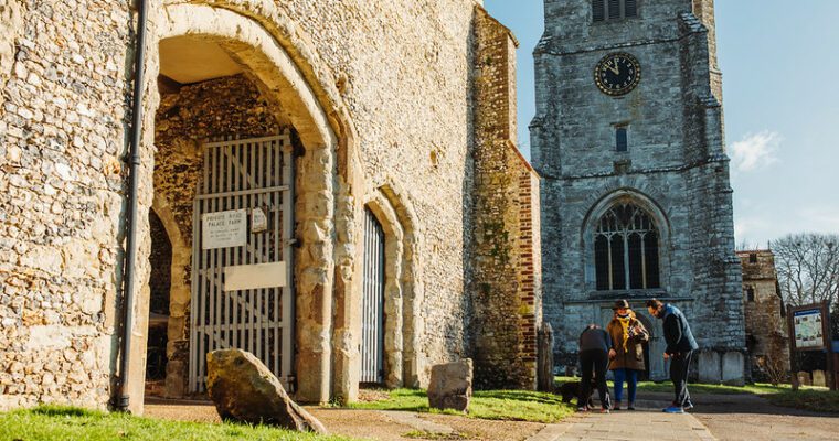
Charing West Lost Landscapes walk
This 5.5 mile trail explores the are to the south-west of Charing village, where vast modern sand pits that gave a glimpse back in time, contrast with ancient woodlands and buildings, including a ruin that may or may not be a chapel.
More information about the walk and a map and guide are available in the Lost Landscapes Heritage Trails Charing leaflet, downloadable on the right hand side of this page.
A lost heathland, a woodland that’s been moved and a special map belonging to an anonymous contributor. These are just some of the highlights on the Lost Landscape Heritage Trails from Charing – two circular walks from the North Downs Way National Trail.
The Charing Heritage Trails have been carefully designed to take in the best heritage features of the area. As you walk you will find that the history has been brought to life by the contributions of local people.
This walk has been created by the North Downs Way National Trail and uses a section of the North Downs Way.
Step by step guide
1. Start in the market place car park next to the church. Walk along the lane out of the carpark away from the church.
2. When you reach the main road through the village, turn left and walk downhill. Pass a turning on your left, keep straight on.
3. When you reach the main road (A20) use the pedestrian crossing to cross over and go down the road (Station Road.)
4. Take the next right (Hither Field)
5. Take the second right from Hither Field, towards the village surgery. You will see a stile on your left and a tarmac path into a new housing estate.
6. Bear left on a grassy path and walk between a fence and the hedges of gardens. After a kissing gate the path does a 90 degree turn then goes under a railway bridge. Follow the treeline on your right and go through a kissing gate, then cross a small bridge. Walk across a field (traditional name, Lower Meadow) towards the house. As you approach the house go through a field gate onto a surfaced driveway.
7. Walk past the house then turn left and go through a field gate. Walk diagonally across the field (traditional name Upper Meadow) towards a kissing gate.
8. Pass through the gate and go through some trees.
9. Turn right and walk to the end of the path.
10. Turn left between two fences
11. Look for a gap on your right and walk through a belt of conifers. Emerge onto a road, cross it and pass through a kissing gate.
12. Go straight ahead across a strip of grass through a second kissing gate onto another road (Caution: This is a quarry road used by heavy lorries.) Cross the road and another kissing gate into a field (traditional name: Horse Pasture). Walk diagonally across the field to a kissing gate in the corner. Pass through the gate and cross the small bridge.
13. Bear right and walk with woodland on your right and a large sand quarry on your left. Follow the edge of the quarry and woodland.
14. At a marked junction turn right, follow the path along the side of a second large quarry.
15. You will see a large modern barn ahead. Turn right and walk until you come to a road.
16. Turn left and follow the road into Charing Heath.
17. Turn right opposite Wind Hill Lane. You will see a hedge, pass through it and cross the field diagonally (traditional name: Sand Field) towards some farm buildings (Burleigh Farm).
18. Reach a narrow lane and turn left following it until it turns into a rough track, past a barn. Follow a path across the field (traditional name: Prebbles.) Cross a bridge and stile and then follow the path across the corner of the field towards another stile.
19. Cross the stile and walk straight ahead towards a corner fence post with a yellow footpath marker. Follow this fence line, keeping it on your right. You will approach a field gate ahead.
20. Before reaching the field gate look on your left for a yellow footpath marker on a post. Walk across to the post then follow the arrow left, along a fence line towards a stile. Cross this stile into another field. Walk across this field diagonally left to the far corner. In the corner you will find a stile. Cross it look to the right and see another stile, cross it, and go straight across a field towards the church and a field gate.
21. When you reach the road cross the stile and turn left (you may want to turn right to go and view the church before continuing your walk from this spot.) Follow this road until you come to a junction.
22. At the junction, turn left. Pass Forge House and take a footpath off to the right through a kissing gate. Walk across the field (Forge Field) towards a second stile. Cross the stile, through a hedgerow, then diagonally cross this large field towards a kissing gate. Pass through the gate then go through a small timber gate to the left onto a bridleway. Follow the bridleway and come to a road (Hurst Lane).
23. Turn right onto Hurst Lane and follow the road between two areas of woodland with a wide strip of grass on your left. Continue along this road (Hurst Lane), pass a turning on your right (Hunger Hatch Lane) and stop to admire the views. Continue along this road (Hurst Lane) (Caution: Heavy Lorries) with the breeze block works and sand pit on your left, until you reach a crossroads.
24. Turn right onto Charing Heath Road. Follow the road until you come to a left hand bend and a footpath off to the left.
25. Take this path near a stream then cross the stream over a metal bridge and through the kissing gate.
26. Turn right and follow a green lane, between two hedges then cross another metal bridge.
27. Reach a stile then walk straight ahead across a field. Cross another stile then come to the small bridge and stile you crossed earlier in the walk. You can now retrace your steps back under the railway bridge, alongside the railway to Hither Field, back to Station Road, turning left back towards the village, across the A20 and into the village.
28. Turn right for the market place where you will reach the end of your walk.