Borough Green to Otford – North Downs Way Rail Trail
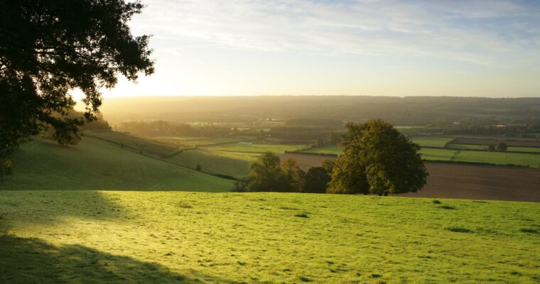
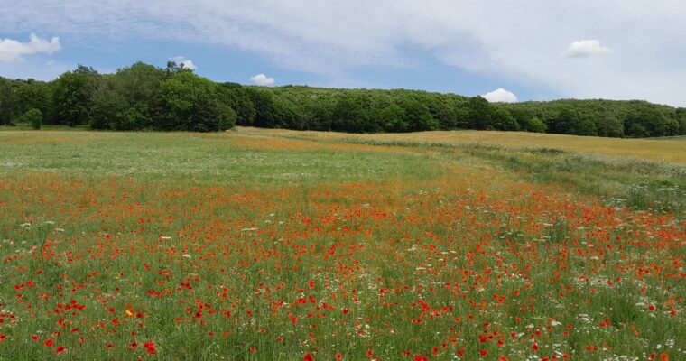
A seven and a half mile hike almost entirely along the North Downs Way with far reaching, panoramic views of the surrounding countryside. The walk includes the two historic villages of Wrotham and Otford as well as rare chalk grassland meadows, woodland and farmland. Located on the Pilgrims’ Way, Wrotham is a historic village characterised by its 13th century church and numerous notable buildings, and it was here in May 1536 that Henry VIII learned of the execution of Anne Boleyn, allowing him to marry Jane Seymour. Further along the route, the North Downs Way milestone marks an almost halfway point, with Farnham 60 miles to the west and Dover 65 miles to the east; nearby, Kemsing Down, a 16-hectare reserve managed by Kent Wildlife Trust, offers excellent panoramic views south to Sevenoaks, west to Leith Hill in Surrey and east to Detling, with chalk downland rich in wildflowers such as common rock-rose, fairy flax, cowslip and several species of orchid. The walk concludes in Otford, a village with a wealth of heritage including the Archbishop’s Palace, the Otford Heritage Trail and a listed duck pond, along with ten heritage panels to discover around the village.
ROUTE DIRECTIONS
- Starting at Borough Green and Wrotham station, walk up to the main road (Wrotham Road). Cross with care and turn left. Continue on this road passing a school on the right.
- Shortly after crossing the motorway, turn left into Borough Green Road and enter Wrotham village. Continue along Borough Green Road, which soon becomes High Street. Just after passing the Rose and Crown on the right and before reaching The Bull, turn left to stay on High Street.
- Continue uphill, passing the church to the right and the village hall to the left, bearing left onto Old London Road. Continue along this road until reaching a turning for Pilgrims’ Way on the left just past a primary school.
- Continue along Pilgrims’ Way, keeping straight when the road becomes a track. Follow this track for about one mile until reaching another road.
- Cross the road with care and continue along the track (North Downs Way) for another mile or so. Just before reaching another road, turn right into a field and cross to a gate on the other side. Continue uphill to reach a second gate at the top.
- Go through the gate and up a flight of steps, turning right at the top onto a road. After about 20m, take the footpath on the left marked North Downs Way.
- Continue along this path through woods until reaching a field. Keep ahead until reaching a waymarked sign and bear to the left, continuing with the tree line to the right. Notice the North Downs Way milestone about halfway along this field. This is part of the St Clere Estate.
- At a footpath junction, turn left, keeping on the North Downs Way and continue ahead when reaching a gap in the trees. Follow the path through the woods. On reaching a gate on the left, continue through a field keeping the tree line to the right until reaching another gate.
- Go through this gate and cross the field, heading for the barn opposite. Go through another gate, walk down the track and exit onto Cotmans Ash Lane through a scissor gate.
- Turn left onto the road, walking a short distance until reaching the NDW footpath sign on the right. Continue following the North Downs Way going through another gate and up three steps to another gate and into a field.
- Continue through the field with the tree line to the left and go through another gate. Continue through three more gates and just before reaching the end of the path, go through the gate on the left, still following the North Downs Way through another gate into a field.
- Cross the field, heading towards the top left hand corner towards yet another gate. Turn right after this gate and continue along the top of the hill. There are fine views towards Sevenoaks and the Greensand Ridge to the left.
- Walk across the top of a field with views to the left then down a short flight of steps and through a gate to the right. Go down some steps crossing a track and up some more steps and through a gate into Kemsing Down Nature Reserve.
- Exit the reserve at Whiteleaf Down, going through a gate and climbing a flight of steps leading to the fence at the top. From here, take a well earned rest to admire the fine views below. Continue along the path with the fence to the right and trees to the left. Turn right at the end, keeping the fence to the right the whole time until reaching a gate onto a lane.
- Turn left onto the lane and follow it around to the right, passing a thatched cottage on the right. Just past the cottage, take the North Downs Way on the left and enter a field through a gate. Go through two more fields and two more gates, following the path all the time until reaching a road.
- Turn left here and at the road junction, keep ahead crossing two roads and go through a gate into a field, still on the North Downs Way. Walk through this field, noticing the Otford Mount trig point on the right.
- Continue along the path, which soon enters woodland and starts to gradually descend until emerging from the trees with a bench on the right and fine views across the Darent Valley beyond.
- Continue down steps, which eventually turn into a driveway, finally reaching the road below. Take care crossing the road and turn right following the road to a junction. Turn left here and continue until reaching some steps on the left which lead down to Otford Station.
 Shoreham & Otford Circular – North Downs Way Rail TrailA five mile walk exploring the stunning countryside of the Darent Valley. The walk includes two historic villages as well as rare chalk grassland meadows,… Otford, ShorehamSave Shoreham & Otford Circular – North Downs Way Rail Trail to favourites